|
|
Maps and Cartography
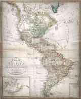
Item #: 100019 Charte von America nach den Neuesten Materialen... (11810)By: Verlag von Geograph. Instituts - Streit, Friedrich Wilhelm. Original hand-colored copper engraving. 58x47 cm (23x18.5”). Map showing Western Hemisphere, Bering Strait and Aleutian... $1,295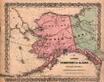
Item #: 100030 Colton’s Territory of Alaska (Russian America). Ceded by Russia to the United States. (1868)By: G. W. & C. B. Colton Original hand-colored steel engraving. $250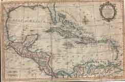
Item #: 100031 Map of the Gulf of Mexico. The islands and countries adjacent. (1795)By: Thomas Kitchin Sr. Orginial Map of the Gulf of Mexico. For the Rev. Dr. Robertson’s History of America $525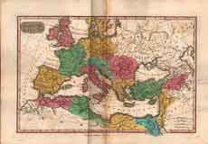
Item #: 100033 Item #: 100036 Colton’s Map of the United States, The Canadas & c. Showing the Railroads, Canals & Stage Roads, With Distances from Place to Place (1854)Steel engraved pocket map with original hand coloring printed on thin “onion skin” paper. States and Territories colored in... $2,350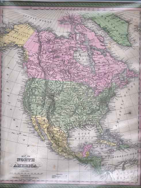
Item #: 100041 Map of North America (1850)By: Thomas Cowperthwait Map of North America, including Russian America for Alaska, Ruperts for Canada, United States, Mexico and Central America. $295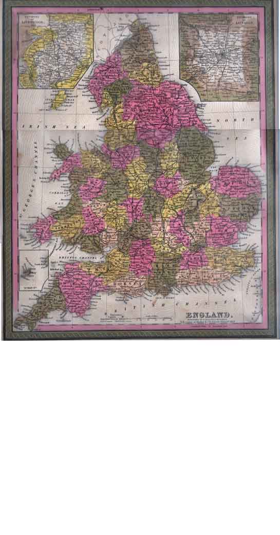
Item #: 110003 Map of England (1847)By: S. Augustus Mitchell A very detailed rare map of England published in 1847 by S. Augustus Mitchell, Philadelphia. Finely colored, with inserts of the... $365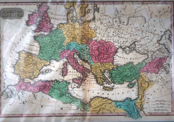
Item #: 110004 Map of Romanum Imperium (Roman Empire) (1827)By: Anthony Finley A rare detailed map of the Roman Empire with place names in Latin. Beautifully colored with some slight toning. $385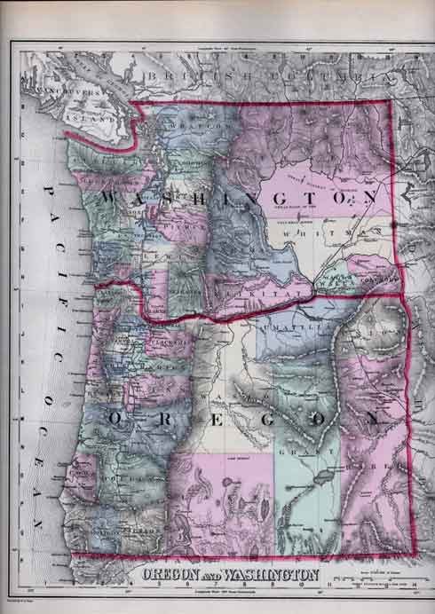
Item #: 110014 Map of Washington and Oregon (Territories) (1879)By: O. W. Gray Map of Washington and Oregon Territories extracted from Gray’s Atlas of the United States. Original hand-coloring. Shows... $185Item #: 110067 Mitchell's Map of New York City, circa 1847 (1848)By: S. Augustus Mitchell A detailed map of the City of New York circa, 1847. Detail of streets, hotels, churches, and political wards. Map extends from... $625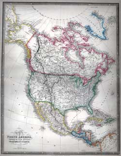
Item #: 130004 Map of North America Exhibiting the Recent Discoveries. Geographical & Nautical (1847)By: James Wyld Map of North America, including Russian America for Alaska, British Possessions for Canada, United States, Mexico and Central... $360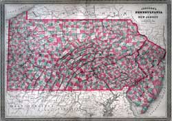
Item #: 130526 Johnson's Map of Pennsylvania and New Jersey by A.J. Johnson and New York (1863)Fine hand-colored map of Pennsylvania and New Jersey delineating townships and county borders. $240
Item #: 130532 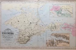
Item #: 130798 A Complete Map of the Crimea, Showing the Military and Carriage Road with Distances from Various Points on the Western Coast, from English and Russian Surveys. (1856)By: Charles Deslilver - Charles Desilver A well engraved and nicely colored double page map from Desilver's "A New Universal Atlas. Map shows the cities, roads, rivers,... $225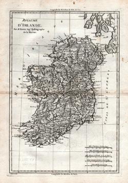
Item #: 130856 Royaume D’Irlande Par M. Bonne, Ing Hydrographe de la Marine (ca. 1787)By: Andre - M. Bonne Charming map of Ireland published in France by one of the leading cartographers of his time, M. Bonne, Hydrographic Engineer to... $300Item #: 130868 Colton’s Map of the World on Mercator’s Projection. Prepared for Henry Bill and Published by J. H. Colton and Co. 172 William St. New York. 1858 (1858)By: J. H. Colton - J. H. Colton Very rare folding pocket map of the World published by J. H. Colton, for Henry Bill. Possibly issued in Henry Bill’s History... $1,200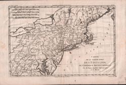
Item #: 130869 Carte de la Partie Nord, Des Etats Unis, de L’Amerique Septentrionale (1783)By: Dien - M. Bonne Ingenieur Hydrographe de la Marine Map of the United States, shortly after the American Revolution. Produced by M. Bonne, Geographer to the King. Showes all bays,... $400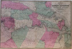
Item #: 130877 Johnson’s Map of the Vicinity of Richmond, and Peninsular Campaign in Virginia. Showing also the interesting localities along the James, Chickahominy and York Rivers. Compiled from the Official Maps of the War Department (1862)This is a rare and important 1862 A. J. Johnson map of the vicinity of Richmond, Virginia, during the American Civil War. The map... $350
|